Following the December 2022 meeting, we are now doing more detailed investigations of Option 1, the north option.

The Mullumbimby to Brunswick Heads cycleway aim is to provide a safe and accessible alternative transport route for the local community. It could link urban areas to schools, workplaces and businesses.
Throughout September and October 2022, we consulted with the community on their preferred route.
The community's feedback was included in a report to Council in December 2022.
Council chose Option 1, the north option, as the preferred route. We are now doing more detailed investigations on this route.
Thank you to everyone who shared their feedback. We received over 800 survey responses.
Cycleway route options
Both of the proposed options are at concept stage only. They are subject to continuing investigation and consultation with:
- Traditional Owners (native title)
- land-owners
- other stakeholders including Crown Lands and Transport for NSW.
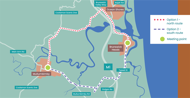
Option 1 - the north option
- Starts in Mullumbimby at corner of Prince Street and Argyle Street, heads north off-road and uses the rail corridor north over the Brunswick River to Synotts Lane and then east towards Smokey Valley Way, connecting to Brunswick Valley Way (at a spot between Orana Road and Rajah Road, Ocean Shores).
- Connects to the north of Brunswick Heads via existing shared path on Brunswick Valley Way that extends all the way to Tweed Street.
Option 2 - the south option
- Starts in Mullumbimby at corner of Prince Street and Argyle Street, heads out of town on-road via Mullumbimby Road (past the industrial estate and across Kings Creek) then takes a turn inland towards Hambly Road, through sugar cane fields directly to Henderson Lane, Saddle Road.
- Connects to the south of Brunswick Heads via Gulgan Road to Tweed Street.
Feedback on the cycleway options
The results of the survey are detailed in the staff report to Council.
Report - Preferred alignment Mullum to Bruns cycleway(PDF, 2MB)
89 percent of all respondents strongly supported the concept of a cycle route connecting Mullumbimby with Brunswick Heads and Ocean Shores.
Of the two route options proposed (see map below):
- 61% of respondents preferred Option 1 - the north option.
- 26% preferred Option 2 - the south option.
- 8% were unsure.
- 5% did not support either of the options proposed.
Likely use of the cycleway routes proposed included:
- 44% will use for recreation, leisure, health and well-being for example going to the park or beach.
- 28 for taking visitors on the cycleway.
- 13% for commuting to work or school.
- 10% for business or tourism purposes.
- 3% wouldn't use it.
- 1% use for other purposes.
Funding
This project is funded by the NSW Government and Byron Shire Council.